![](/images/other/stat-length.png)
![Randonnée Marche La Ferté-sous-Jouarre - Ferté sous Jouarre et la Meulière - Photo](https://media.geolcdn.com/t/1900/400/e6908593-8b7c-485b-a9db-a8ba1355face.jpg&format=pjpeg&maxdim=2)
Ferté sous Jouarre et la Meulière
pikibangi
Utilisateur
![Longueur](/images/other/stat-length.png)
Longueur
22 km
![Altitude max](https://static1.geolcdn.com/siteimages/upload/files/1508320355ic_sort_altitude_max_24dp.png)
Altitude max
190 m
![Dénivelé positif](https://static1.geolcdn.com/siteimages/upload/files/1508320355ic_sort_den_pos_24dp.png)
Dénivelé positif
286 m
![Km-Effort](/images/other/stat-length.png)
Km-Effort
25 km
![Altitude min](https://static1.geolcdn.com/siteimages/upload/files/1508320355ic_sort_altitude_min_24dp.png)
Altitude min
49 m
![Dénivelé négatif](https://static1.geolcdn.com/siteimages/upload/files/1508320355ic_sort_den_neg_24dp.png)
Dénivelé négatif
286 m
![Boucle](https://static1.geolcdn.com/siteimages/upload/files/16400158638029165_repeat_loop_refresh_sync_direction_icon.png)
Boucle
Oui
Date de création :
2022-12-04 08:23:20.949
Dernière modification :
2022-12-05 12:28:22.115
![Marche](https://static1.geolcdn.com/sitytour/trail-icons/101.png)
4h36
Difficulté : Très difficile
![Scannez ce code QR pour ouvrir la randonnée dans l'application SityTrail](https://capi.geolives.com/qq0zvz2zws4bq2lad0pu/sitytour/trails/3473662/qr.png?size=200)
Application GPS de randonnée GRATUITE
À propos
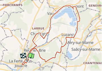
Randonnée Marche de 22 km à découvrir à Île-de-France, Seine-et-Marne, La Ferté-sous-Jouarre. Cette randonnée est proposée par pikibangi.
Description
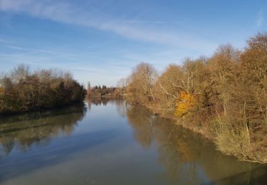
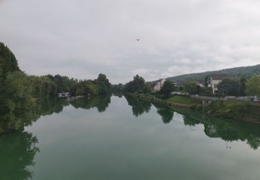
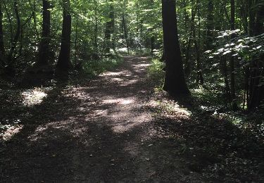
Boucle au départ de la Ferté sous Jouarre le long de la marne passage devant un apiculteur ou on peut acheter du miel puis le parcours passe ou on extrayait la pierre meulière et de l'argile
Localisation
Pays :
France
Région :
Île-de-France
Département/Province :
Seine-et-Marne
Commune :
La Ferté-sous-Jouarre
Localité :
Unknown
Départ:(Dec)
Départ:(UTM)
510048 ; 5422046 (31U) N.
Commentaires
Randonnées à proximité
![Randonnée Marche Jouarre - Jouarre et ses cryptes - Photo](https://media.geolcdn.com/t/375/260/ext.jpg?maxdim=2&url=https%3A%2F%2Fstatic1.geolcdn.com%2Fsiteimages%2Fupload%2Ffiles%2F1553511878bg_sport_marche.png)
![Marche Marche](https://static1.geolcdn.com/sitytour/trail-icons/101.png)
Jouarre et ses cryptes
Marche
Moyen
(4)
Jouarre,
Île-de-France,
Seine-et-Marne,
France
![](/images/other/stat-length.png)
15,4 km | 18,4 km-effort
4h 0min
![](https://static1.geolcdn.com/siteimages/upload/files/16400158638029165_repeat_loop_refresh_sync_direction_icon.png)
Oui
![Randonnée Marche La Ferté-sous-Jouarre - RP51-08 La Ferté-sous-Jouarre à Changis-sur-Marne - Photo](https://media.geolcdn.com/t/375/260/ef75080a-2b54-498f-83f5-ffb33b9d0314.jpg&format=jpg&maxdim=2)
![Marche Marche](https://static1.geolcdn.com/sitytour/trail-icons/101.png)
RP51-08 La Ferté-sous-Jouarre à Changis-sur-Marne
Marche
Difficile
La Ferté-sous-Jouarre,
Île-de-France,
Seine-et-Marne,
France
![](/images/other/stat-length.png)
15,3 km | 19 km-effort
4h 18min
![](https://static1.geolcdn.com/siteimages/upload/files/16400158638029165_repeat_loop_refresh_sync_direction_icon.png)
Non
![Randonnée Marche La Ferté-sous-Jouarre - GR15-09 La Ferté-sous-Jouarre à Saâcy-sur-Marne - Photo](https://media.geolcdn.com/t/375/260/1d1275d6-db81-46a6-95f5-294c7ac7d0b6.jpg&format=jpg&maxdim=2)
![Marche Marche](https://static1.geolcdn.com/sitytour/trail-icons/101.png)
GR15-09 La Ferté-sous-Jouarre à Saâcy-sur-Marne
Marche
Difficile
La Ferté-sous-Jouarre,
Île-de-France,
Seine-et-Marne,
France
![](/images/other/stat-length.png)
13,4 km | 17,1 km-effort
3h 53min
![](https://static1.geolcdn.com/siteimages/upload/files/16400158638029165_repeat_loop_refresh_sync_direction_icon.png)
Non
![Randonnée Marche La Ferté-sous-Jouarre - LaFerteSousJouarre-boucle-2-6-2024-20Km - Photo](https://media.geolcdn.com/t/375/260/91dca338-45d3-4638-9df4-956dc5b0281b.jpg&format=jpg&maxdim=2)
![Marche Marche](https://static1.geolcdn.com/sitytour/trail-icons/101.png)
LaFerteSousJouarre-boucle-2-6-2024-20Km
Marche
Facile
La Ferté-sous-Jouarre,
Île-de-France,
Seine-et-Marne,
France
![](/images/other/stat-length.png)
20 km | 25 km-effort
6h 44min
![](https://static1.geolcdn.com/siteimages/upload/files/16400158638029165_repeat_loop_refresh_sync_direction_icon.png)
Oui
![Randonnée Marche Saint-Cyr-sur-Morin - godillot - Photo](https://media.geolcdn.com/t/375/260/ext.jpg?maxdim=2&url=https%3A%2F%2Fstatic1.geolcdn.com%2Fsiteimages%2Fupload%2Ffiles%2F1553511878bg_sport_marche.png)
![Marche Marche](https://static1.geolcdn.com/sitytour/trail-icons/101.png)
godillot
Marche
Très facile
(1)
Saint-Cyr-sur-Morin,
Île-de-France,
Seine-et-Marne,
France
![](/images/other/stat-length.png)
21 km | 26 km-effort
5h 55min
![](https://static1.geolcdn.com/siteimages/upload/files/16400158638029165_repeat_loop_refresh_sync_direction_icon.png)
Oui
![Randonnée Marche La Ferté-sous-Jouarre - LA FERTE S/JOUARRE BOUCLE 13 KM - Photo](https://media.geolcdn.com/t/375/260/ext.jpg?maxdim=2&url=https%3A%2F%2Fstatic1.geolcdn.com%2Fsiteimages%2Fupload%2Ffiles%2F1553511878bg_sport_marche.png)
![Marche Marche](https://static1.geolcdn.com/sitytour/trail-icons/101.png)
LA FERTE S/JOUARRE BOUCLE 13 KM
Marche
Très facile
(1)
La Ferté-sous-Jouarre,
Île-de-France,
Seine-et-Marne,
France
![](/images/other/stat-length.png)
12,4 km | 15,6 km-effort
3h 20min
![](https://static1.geolcdn.com/siteimages/upload/files/16400158638029165_repeat_loop_refresh_sync_direction_icon.png)
Oui
![Randonnée Marche Jouarre - Abbaye de Jouarrre Grand parcours - Photo](https://media.geolcdn.com/t/375/260/ext.jpg?maxdim=2&url=https%3A%2F%2Fstatic1.geolcdn.com%2Fsiteimages%2Fupload%2Ffiles%2F1553511878bg_sport_marche.png)
![Marche Marche](https://static1.geolcdn.com/sitytour/trail-icons/101.png)
Abbaye de Jouarrre Grand parcours
Marche
Facile
(2)
Jouarre,
Île-de-France,
Seine-et-Marne,
France
![](/images/other/stat-length.png)
20 km | 25 km-effort
5h 5min
![](https://static1.geolcdn.com/siteimages/upload/files/16400158638029165_repeat_loop_refresh_sync_direction_icon.png)
Oui
![Randonnée Marche La Ferté-sous-Jouarre - Circuit au départ de La Ferté sous Jouarre - Photo](https://media.geolcdn.com/t/375/260/ext.jpg?maxdim=2&url=https%3A%2F%2Fservices.sitytrail.com%2FGeolivesWS%2FDownloadMedia.ashx%3FTrailID%3D618388%26Media%3D20160821101138.jpg)
![Marche Marche](https://static1.geolcdn.com/sitytour/trail-icons/101.png)
Circuit au départ de La Ferté sous Jouarre
Marche
Moyen
La Ferté-sous-Jouarre,
Île-de-France,
Seine-et-Marne,
France
![](/images/other/stat-length.png)
21 km | 25 km-effort
5h 24min
![](https://static1.geolcdn.com/siteimages/upload/files/16400158638029165_repeat_loop_refresh_sync_direction_icon.png)
Oui
![Randonnée A pied Jouarre - Le chemin de St Colomban en Ile de France Etape 3 De Jouarre à Meaux - Photo](https://media.geolcdn.com/t/375/260/ext.jpg?maxdim=2&url=https%3A%2F%2Fstatic1.geolcdn.com%2Fsiteimages%2Fupload%2Ffiles%2F1545311037marcheuse_200dpi.jpg)
![A pied A pied](https://static1.geolcdn.com/sitytour/trail-icons/100.png)
Le chemin de St Colomban en Ile de France Etape 3 De Jouarre à Meaux
A pied
Difficile
Jouarre,
Île-de-France,
Seine-et-Marne,
France
![](/images/other/stat-length.png)
32 km | 38 km-effort
8h 33min
![](https://static1.geolcdn.com/siteimages/upload/files/16400158638029165_repeat_loop_refresh_sync_direction_icon.png)
Non